9 feet of snow wallops California mountains as brutal cold invades U.S.

Add Axios as your preferred source to
see more of our stories on Google.
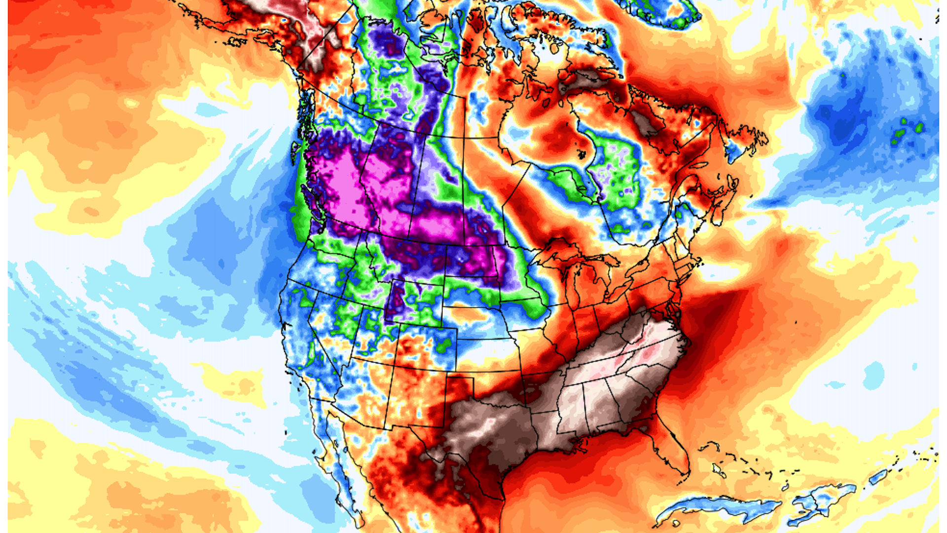
Computer model projection shows temperature departures from average forecasted for Dec. 29. Photo: Weatherbell.com
California's ski resorts are digging out from under 5 to 9 feet of snow that has fallen over the last several days from a series of storms. And more snow is on the way.
The big picture: A large dip, or trough, in the jet stream across the West is allowing frigid conditions and a relentless series of storms to bring record-breaking snowfall into the Sierra Nevada Mountains. The snow has closed major interstates and even forced the shut down of several ski resorts.
- According to the National Weather Service, between 6 and 9 feet of snow has fallen in the Sierra Nevada Mountains since Wednesday. Northstar California Resort picked up 15 inches of new snow since Monday.
- Some one-week snowfall totals may eclipse 10 feet as more storms bring additional rounds of snow through Wednesday.
- At UC Berkeley's Central Sierra Snow Lab, 202.1 inches have fallen in December, making it the snowiest such month on record there, and the third-snowiest month of all time.
- The snow is good news for a state that entered the winter mired in drought, since winter snow cover is used for water resources during the dry season. While parts of the state are still designated as being in "exceptional" drought, the worst category on the scale, Northern California is seeing meaningful relief.
Threat level: Road traffic is beginning to reopen in parts of the Sierras, but closures continued Tuesday morning for important routes, including across the California-Nevada border.
- In addition to the snow, much of the West, including Seattle and Portland, Oregon, are experiencing unusually cold conditions, as an Arctic air mass seeps across the Canadian border. The Weather Service warned of the potential for hypothermia and frostbite in Seattle, where overnight lows have hovered near 20°F.
- In Portland, even colder temperatures are expected again Tuesday night on the eastern side of the city, as air temperatures plummet in the Columbia River Gorge. Wind chills could hover close to 0°F, and there is a risk of pipes bursting in homes, the Weather Service warned.
- However, the cold weather in the Pacific Northwest pales in comparison to the frigid conditions moving into Montana and the Dakotas. There, wind chills are expected to reach minus-50°F Tuesday night, with daytime high temperatures failing to rise above 0°F during the day on Tuesday, Wednesday and Thursday.
- Wind chills that low can cause frostbite on exposed skin within just a few minutes, the NWS warned.
Yes, but: The cold stands in stark contrast to the record heat still affecting the South and Southeast, where record highs are expected through Wednesday.
- The warm weather may yield an 85 to 90°F temperature contrast within the lower 48 states alone.
- Numerous cities, including Dallas and Oklahoma City, are almost assured to have their warmest December on record, with locations along the East Coast, including Washington and Boston ranking in their top 5 warmest.
What to expect: The next few days will feature more of the same, with a cold, unsettled weather pattern in the West, and high avalanche danger in the Sierras. Frigid conditions will become firmly established in the northern Plains, and gradually shift southeastward into Minnesota, based on computer model projections.
- The heart of the cold air lies to the north, across British Columbia, where some of the coldest conditions since the 1960s are occurring.
- Temperatures in many locations are not rising above the minus-teens Fahrenheit for daytime highs this week, an unusual occurrence for this province.
Of note: British Columbia is in the running for the top spot in North America for extreme weather events in 2021, with a scorching heat wave and related wildfires last summer, devastating floods in the fall and now this once-in-a-generation cold snap. Lytton, B.C., reached 121°F on June 29 to set the country's all-time record high, only to burn in a fire the next day.
- Studies have already tied some of these extremes to climate change, particularly the fires, heat and floods.
