Tropical Storm Henri prompts hurricane warnings for Connecticut, New York

Add Axios as your preferred source to
see more of our stories on Google.
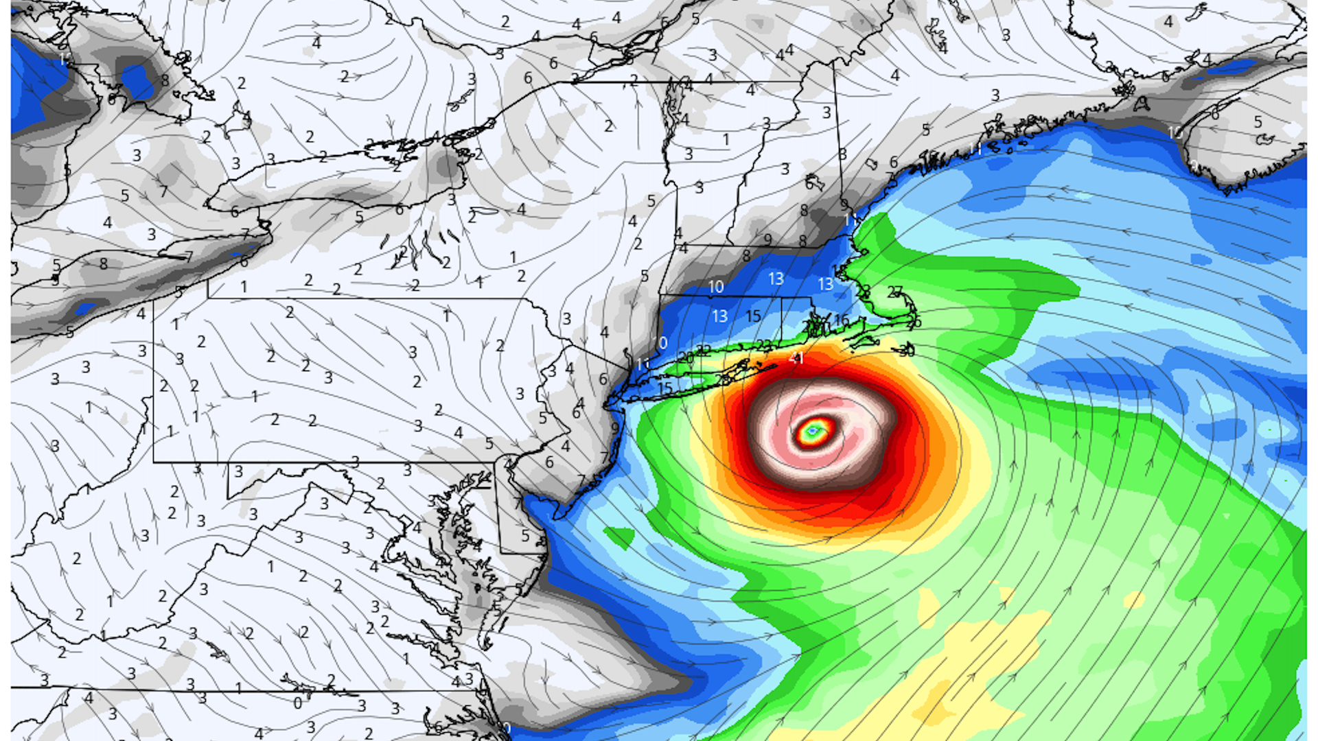
Model projection showing Hurricane Henri approaching Southern New England on Aug. 22, 2021. (weatherbell.com
Tropical Storm Henri, currently spinning its way north-northwest about 270 miles southeast of Cape Hatteras, North Carolina, is likely to become the first hurricane to make landfall in southern New England in 30 years.
Why it matters: Factors ranging from soggy soils from previous rainstorms to astronomical high tides, and Henri's slow forward motion will combine to create a uniquely dangerous scenario for New England beginning Sunday and lasting through at least Monday.
Driving the news: Tropical Storm Henri has survived a battle with strong upper level winds that have tipped over its towering thunderstorms, putting a lid on its intensification. However, those winds are projected to slacken just as the storm traverses the warm waters of the Gulf Stream in the next few days.
- As of 5 p.m. ET, the storm was on the cusp of hurricane status, with maximum sustained winds of 70 mph, indicating the storm was beginning to intensify.
- The National Hurricane Center predicts the storm will become a Category 1 or 2 hurricane within the next 24 hours, before weakening during its approach to a most likely landfall zone between Long Island and southern Rhode Island on Sunday afternoon or evening.
- Eversource, a Connecticut utility, is warning its customers to prepare to go without power for up to 10 days, per an NBC News affiliate.
Context: While New England has seen damaging hurricanes before, they are not common. Additionally, when storms get to this high of a latitude, they tend to be moving quickly off to the north-northeast, captured by the jet stream winds aloft.
- Oftentimes, storms in the position where Henri is now tend to curve harmlessly out to sea, but the existence of a high pressure area to the northeast and a low pressure area to the west are projected to funnel Henri up the coast instead.
According to a National Oceanic and Atmospheric Administration database, only five hurricanes have made landfall within 100 miles of Boston since 1950, and the ones on the list are notorious for their damage to coastal areas in particular.
- These include Hurricanes Carol in 1954, Donna in 1960, Gloria in 1985, and the most recent such storm, Hurricane Bob in 1991.
- However, Henri is forecast to be different than every one of these storms, in that it will be moving far more slowly when it nears and crosses the coast. This could lead to rapid weakening once it moves over land, but also prolonged periods of high winds and pounding surf, plus coastal flooding that lasts for more than one high tide cycle.
Threat level: The exact intensity and track forecast for Henri still have considerable uncertainty, though the possibility of a landfall on Cape Cod is diminishing while a landfall along Long Island, with potentially significant impacts across Connecticut and Rhode Island in particular.
- The National Hurricane Center has hoisted hurricane warnings, storm surge warnings, and watches for the areas most likely to see the storm's most serious effects. A storm surge — the water driven ashore by the storm's winds on top of tide levels of three to five feet — is expected along and to the east of where the center makes landfall.
- New York City is under tropical storm and storm surge watches. Warnings are in effect for parts of the metro area, to the east and northeast, for the first time since Hurricane Irene struck in 2011.
- "Dangerous storm surge inundation is expected to begin Sunday in portions of Long Island, Connecticut, Rhode Island, and southeastern Massachusetts, where a Storm Surge Warning has been issued," the Hurricane Center stated.
- What's especially unusual about this storm, though, is that just as Henri nears the coast, atmospheric steering currents are forecast to collapse, causing the storm to slow to a crawl and potentially pivot northwestward, hitting the coast of Long Island at a nearly 90-degree angle.
- The storm's slow movement and likely interaction with higher elevations in western Massachusetts and parts of New York State make the threat of inland flooding particularly serious.
- Since Hurricane Bob struck New England in 1991, sea levels have risen due largely to human-caused climate change. This makes any surge more dangerous today than it was during the last hurricane this area faced.
What's next: The Hurricane Center and the Boston office of the National Weather Service are urging residents of southern New England, as well as New York (particularly from New York City to the tip of Long Island), to prepare for high winds, heavy rains and the potential for prolonged power outages late this weekend and early next week.
- Expect the track and intensity forecast to be fine-tuned Friday and Saturday, and any fluctuations in these expectations will have a major influence on which areas are most likely to see the brunt of the storm.
This is a developing story. Please check back for updates.
