Unprecedented heat wave set to roast Pacific Northwest

Add Axios as your preferred source to
see more of our stories on Google.
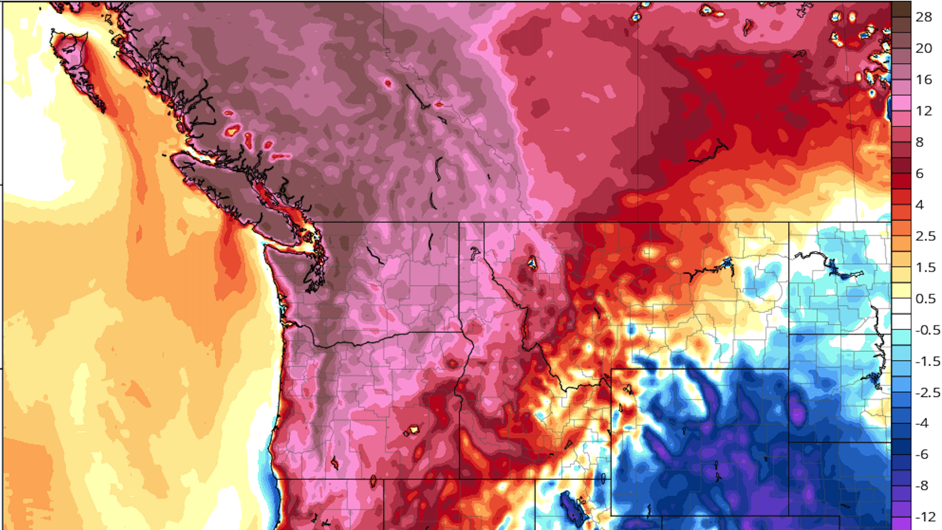
Computer model projection showing temperature departures from average on Monday, June 28, 2021. (tropicaltidbits.com)
The most severe heat wave on record in the Pacific Northwest and southwestern Canada kicks into high gear Friday and will intensify throughout the weekend and into next week.
Why it matters: Heat waves like this one are significant public health threats, particularly in areas like the Northwest, where many people lack air conditioning.
- Extreme heat tends to be the biggest weather-related killer each year in the U.S., outranking even tornadoes and hurricanes.
- Numerous daily, monthly and all-time high temperature records will be shattered.
- More than 13 million residents from Northern California through much of Oregon and Washington, and eastward to Idaho are under excessive heat warnings.
The big picture: Extreme heat events are directly tied to human-caused global warming, with studies showing that severe heat events are now on average about 3°F to 5°F hotter than they would be without emissions of greenhouse gases from fossil fuel burning, deforestation and other activities.
- Some recent studies have shown that certain extreme heat events could not have occurred without the added boost from human-caused warming.
What they're saying: NWS forecasters in Seattle said Friday they “have never seen Pacific Northwest data like this.”
- The National Weather Service, which is typically cautious in its word choices with the public, is not holding back in its messaging this time around.
- The agency's forecast office in Portland, for example, issued a forecast discussion Friday morning stating, "...UNPRECEDENTED HEAT WAVE EXPECTED THIS WEEKEND INTO NEXT WEEK..."
- Agency social media accounts have also been relaying hot weather safety tips and directing people to cooling shelters.
Driving the news: A highly unusual weather pattern is setting up over the Pacific Northwest, with a record-strong high-pressure area aloft — known as a "heat dome" — settling over the region and intensifying through Monday. Such a heat dome, if it reaches the strength that computer models are projecting, would yield temperature departures from average of between 25 and 45°F across multiple states and British Columbia.
- Weather balloons launched from NWS offices in the Northwest Friday found the freezing level at or above 18,000 feet in some areas, prompting concerns about meltwater runoff from unusually warm weather affecting mountain snow fields and glaciers.
- This heat, combined with a worsening drought, will raise the risk of wildfires across multiple Western states.
- It will also cause power demand to spike.
By the numbers: Virtually all of Oregon and Washington, plus portions of California, Idaho and Montana, are under excessive heat watches and warnings. This is the case even in downtown Portland and Seattle.
- Portland, Oregon, is forecast to reach low triple-digits on Saturday through at least Monday. The city is likely to break its June heat record, its record for most 100-degree days in June, and surpass its all-time high of 107°F, perhaps by a few degrees.
- In Seattle, where the average high temperature this time of year is in the low-to-mid 70s, the National Weather Service (NWS) predicts a high of 102°F on Sunday, which would break the record for the city's hottest temperature during the month of June.
- Seattle's all-time high temperature record is 103°F, and the city has only seen three 100-degree days in its history.
- Medford, Oregon and Spokane, Washington, are also predicted to shatter their all-time high temperature record by a few degrees.
- The heat will be most intense in inland areas of Washington and Oregon. There, temperatures are forecast to soar to between 100°F and 115°F on Saturday through Tuesday, and remain extremely hot through much of next week.
- Nearly every location along the I-5 corridor from Northern California to Washington is likely to set a monthly or even an all-time high temperature record during this event.
- Canada will also see extreme heat, and it's possible the country's all-time high temperature record of 113°F (45°C) will be equaled or eclipsed.
How it works: One of the reasons why the Pacific Northwest will get so hot is that the core of the heat dome will be parked to the north-northeast of the region for several days.
- Due to the clockwise flow of air around the high, this will produce surges of air moving from high-to-lower elevation areas in Idaho, Washington and Oregon.
- When air sinks, such as when it moves out of mountainous regions and into valleys, it compresses, increasing temperatures and getting drier in the process
.
